
This page is part of an mirror of © FOTW Flags Of The World website
This website is devoted to the science of vexillology (the study of flags).
All illustrations presented on this website serve exclusively to provide information in the context of vexillology.
The authors and hosts of this site explicitly distance themselfes from any symbols of unconstitutional organizations that may be depicted here.
Amstelveen (The Netherlands)
Noord-Holland province
Last modified: 2018-12-15 by rob raeside
Keywords: amstelveen |
Links: FOTW homepage |
search |
disclaimer and copyright |
write us |
mirrors
 Shipmate Flagchart : http://www.flagchart.net
See also:
Amstelveen municipality
Amstelveen, province Noordholland, 77.279 inhabitants, 4238 hectares. Amstelveen
is a southern suburb of Amsterdam; before 1964 its official name was Nieuweramstel,
under which name it contained many small villages along the Amstel river
and settlements built in the environment of Amsterdam. It calls itself
'Stad in 't groen' - city in green, because a lot of its area is
occupied by the "Bosplan", which is a large forest area, created
forcibly by Amsterdam unemployed people in the 1930's. The Amstelveners
can furthermore enjoy the lovely tones of the nearby Schiphol airport and
its practically noiseless planes.
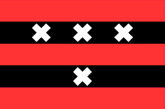
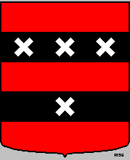
The flag is a banner of arms, where the top three strips are identical
to the flag of Amsterdam and the bottom two add an extra x. The x's are
said to be derived from the Coat of Arms of the Persijn family, who owned this land
in the 13th century. Amstelveen consists of Amstelveen (seat), Bovenkerk,
Nes aan de Amstel, and Ouderkerk aan de Amstel (part).
Jarig Bakker, 20 June 2001
Amstelveen Coat of Arms
 International
Civic Arms : http://www.ngw.nl/
International
Civic Arms : http://www.ngw.nl/
Advertisement from our sponsor:
Bei Fahnenversand.de erhalten Sie eine Vielzahl an hochwertigen Flaggen, Pins und Aufnähern, zum Beispiel:


Bestellen Sie Ihre Fahnen im Flaggen-Shop bei Fahnenversand.de