This page is part of an mirror of © FOTW Flags Of The World website
This website is devoted to the science of vexillology (the study of flags).
All illustrations presented on this website serve exclusively to provide information in the context of vexillology.
The authors and hosts of this site explicitly distance themselfes from any symbols of unconstitutional organizations that may be depicted here.
Last modified: 2022-11-19 by rick wyatt
Keywords: shelburne | massachusetts | franklin county |
Links: FOTW homepage |
search |
disclaimer and copyright |
write us |
mirrors
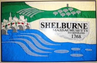
![[Flag of Shelburne, Massachusetts]](../images/u/us-mashb.gif) image by Masao Okazaki, 14 October 2022
image by Masao Okazaki, 14 October 2022
based on photo located by Valentin Poposki,
13 October 2022
See also:
An ornate flag with a local scene comprising fields and orchards in the distance, a white middle ground bearing the town name and date, and a water fall and flowing river in the foreground. The village appears above the waterfall in the fly. Shelburne is in Franklin County.
From www.co.franklin.ma.us/shelburn.htm:
The land which is now Shelburne was incorporated in old Hampshire County as early as 1662. In 1712 on petition of Rev. John Williams, the famous "redeemed captive of Deerfield," the territory of Shelburne was annexed to Deerfield and commonly known as "Deerfield Pasture" and "Deerfield Northwest Pasture," or more briefly "the Northwest." First settlements were made between 1752 and 1756 by Jonathan Catllin and James Ryder of Deerfield, but because of French and Indian wars, these settlements near Salmon Falls (now Shelburne Falls) were abandoned. The General Courts granted a charter June 21, 1768. The first district meeting was held October 31, 1768, in the home of Daniel Nims. Thus Shelburne became an independent district. It was seven years later in 1775 when Shelburne was made a town by a general act under which districts became towns.Dov Gutterman, 18 November 2002
Advertisement from our sponsor:
Bei Fahnenversand.de erhalten Sie eine Vielzahl an hochwertigen Flaggen, Pins und Aufnähern, zum Beispiel: