This page is part of an mirror of © FOTW Flags Of The World website
This website is devoted to the science of vexillology (the study of flags).
All illustrations presented on this website serve exclusively to provide information in the context of vexillology.
The authors and hosts of this site explicitly distance themselfes from any symbols of unconstitutional organizations that may be depicted here.
Last modified: 2022-07-09 by rick wyatt
Keywords: nampa | idaho | canyon county |
Links: FOTW homepage |
search |
disclaimer and copyright |
write us |
mirrors
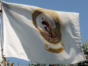
![[Flag of Nampa, Idaho]](../images/u/us-idnam.gif) image by Masao Okazaki, 17 April 2021
image by Masao Okazaki, 17 April 2021
based on image located by Valentin Poposki, 15 January 2008
Source: www.waymarking.com
See also:
"Nampa is the largest city in Canyon County, Idaho, United States, and the second largest in the state. Only the capital city, Boise, is larger. As of the 2000 Census the population of Nampa was 51,867 (2006 estimate: 79,587).
Nampa is located about 20 miles west of Boise along Interstate 84. The city is considered part of the Boise metropolitan area.
Nobody knows for sure where Nampa got its name. The belief is that it came from a Native American word for moccasin. Native Americans stuffed their moccasins with sagebrush to keep warm, making a larger footprint." - from Wikipedia
A photo of the flag can be seen in Waymarking website.
Valentin Poposki, 15 January 2008
Recent photos show that the flag currently being used is the blue one on the
Waymarking page. The blue background of the seal is moved to the back of the
flag.
https://www.facebook.com/cityofnampa.us/photos/10162162444330713
https://www.facebook.com/cityofnampa.us/photos/10162503976155713
Masao Okazaki, 17 April 2021
![[City seal]](../images/u/us-idnam).gif) image located by Paul Bassinson, 5 July 2019
image located by Paul Bassinson, 5 July 2019
Source:
https://www.cityofnampa.us/
Paul Bassinson, 5 July 2019
Advertisement from our sponsor:
Bei Fahnenversand.de erhalten Sie eine Vielzahl an hochwertigen Flaggen, Pins und Aufnähern, zum Beispiel: