This page is part of an mirror of © FOTW Flags Of The World website
This website is devoted to the science of vexillology (the study of flags).
All illustrations presented on this website serve exclusively to provide information in the context of vexillology.
The authors and hosts of this site explicitly distance themselfes from any symbols of unconstitutional organizations that may be depicted here.
Last modified: 2024-06-22 by rick wyatt
Keywords: bethel heights | arkansas | benton county |
Links: FOTW homepage |
search |
disclaimer and copyright |
write us |
mirrors
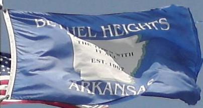
![[Flag of Bethel Heights, Arkansas]](../images/u/us-arbeh.gif) image by Masao Okazaki, 30 March 2021
image by Masao Okazaki, 30 March 2021
based on photo located by Valentin Poposki, 31 May 2012
See also:
A blue flag with a map of Arkansas in white, the name and state written above and below, and the slogan on the map.
From what I can see, there is a star at the location of the town (bottom of Benton Co) and the state map says "The Town with it all." 1967 was the establishing of the city.
Zachary Harden, 31 May 2012
Bethel Heights disincorporated in 2020, then was annexed by Springdale.
Daniel Rentería, 31 May 2024
Advertisement from our sponsor:
Bei Fahnenversand.de erhalten Sie eine Vielzahl an hochwertigen Flaggen, Pins und Aufnähern, zum Beispiel: