This page is part of an mirror of © FOTW Flags Of The World website

This website is devoted to the science of vexillology (the study of flags).
All illustrations presented on this website serve exclusively to provide information in the context of vexillology.
The authors and hosts of this site explicitly distance themselfes from any symbols of unconstitutional organizations that may be depicted here.


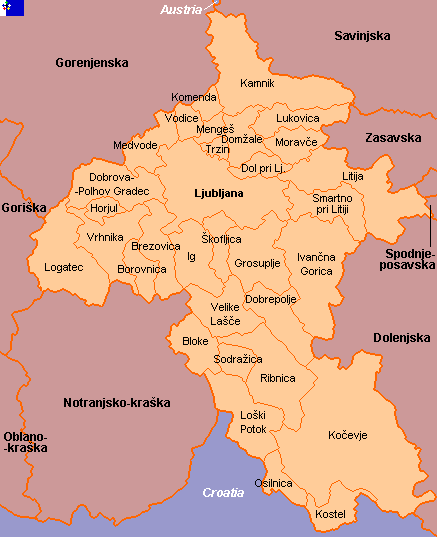
Clickable map of Osrednjeslovenska (Slovenia)

Last modified: 2013-06-22 by ivan sache
Keywords: osrednjeslovenska |
Links: FOTW homepage | search | disclaimer and copyright | write us | mirrors


See also:

Civic municipalities in bold font.
Map as of October 2002 - Municipality of Log - Dragomer, formed in 2006, not shown - Municipalities of Kočevje, Kostel, Loški Potok, Osilnica, Ribnica and Sodražica transferred to Jugovzhodna Slovenia - Municipality of Bloke transferred to Notranjsko-kraška.

Copyright: FOTW Osrednjeslovenska map by António Martins and Željko Heimer and boundaries’ data by Jarig Bakker. If you wish to reuse them on your website, read our copyright rules.

Clickable map of the World
 

Advertisement from our sponsor:

Bei Fahnenversand.de erhalten Sie eine Vielzahl an hochwertigen Flaggen, Pins und Aufnähern, zum Beispiel:
Fahne Volksrepublik China
(90 x 60 cm) Flagge Flaggen Fahne Fahnen kaufen bestellen Shop Stockflaggen Serbien und Montenegro
 (45 x 30 cm) Flagge Flaggen Fahne Fahnen kaufen bestellen Shop Fahne Philippinen
 (90 x 60 cm) Flagge Flaggen Fahne Fahnen kaufen bestellen Shop Flagge Frohe Ostern - Jongleur
 (150 x 90 cm) Flagge Flaggen Fahne Fahnen kaufen bestellen Shop Flagge Benin
 im Querformat (Glanzpolyester) Flagge Flaggen Fahne Fahnen kaufen bestellen Shop
Bestellen Sie Ihre Fahnen im Flaggen-Shop bei Fahnenversand.de