
This page is part of an mirror of © FOTW Flags Of The World website
This website is devoted to the science of vexillology (the study of flags).
All illustrations presented on this website serve exclusively to provide information in the context of vexillology.
The authors and hosts of this site explicitly distance themselfes from any symbols of unconstitutional organizations that may be depicted here.
Vaals (The Netherlands)
Limburg province
Last modified: 2018-12-15 by rob raeside
Keywords: vaals |
Links: FOTW homepage |
search |
disclaimer and copyright |
write us |
mirrors
 Shipmate Flagchart : http://www.flagchart.net
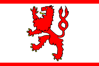
adopted 11 Mar 1963
See also:
Vaals municipality
Population (1 Jan 2003): 10.621; area: 23,90 km². Settlements: Vaals
(seat), Camerig, Cottessen, Harles, Holset, Lemiers, Mamelis, Melleschet,
Oud Lemiers, Raren, Rott, Vijlen, Wolfhaag. Vaals is mostly known for the
"Drielandenpunt" (threecountriespoint), where the borders of the
Netherlands, Belgium, and Germany meet. It is at the same time the highest
point in the Netherlands: 322,5 m above sealevel. This used to be a "Vierlandenpunt"
(four countries), when Moresnet (Belgium) was
a neutral exclave. See Kelmis (Belgium).
Flag: adopted 11 Mar 1963 by municipal resolution. Description: rectangular
white, with in the center a red lion armed yellow; on top and bottom a
narrow horizonal red stripe.
Visser reports a square banner.
Source: the Vaals municipal webpage.
Derkwillem
Visser's "Gemeentewapens en Vlaggen Koninkrijk der Nederlanden:, 2001.
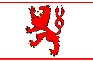
Historical flag
 Shipmate Flagchart : http://www.flagchart.net
Advertisement from our sponsor:
Bei Fahnenversand.de erhalten Sie eine Vielzahl an hochwertigen Flaggen, Pins und Aufnähern, zum Beispiel:


Bestellen Sie Ihre Fahnen im Flaggen-Shop bei Fahnenversand.de