
This page is part of an mirror of © FOTW Flags Of The World website
This website is devoted to the science of vexillology (the study of flags).
All illustrations presented on this website serve exclusively to provide information in the context of vexillology.
The authors and hosts of this site explicitly distance themselfes from any symbols of unconstitutional organizations that may be depicted here.
Kerkrade (The Netherlands)
Limburg province
Last modified: 2018-12-15 by rob raeside
Keywords: kerkrade |
Links: FOTW homepage |
search |
disclaimer and copyright |
write us |
mirrors
 Shipmate Flagchart : http://www.flagchart.net
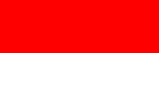
not officially adopted.
Other Kerkrade pages:
See also:
Kerkrade municipality
Number of inhabitants (1 Jan 2003): 50.292; area: 21,94 km². Settlements:
Kerkrade (seat), Eygelshoven.
Kerkrade is in southeast Limburg against the German border. It is built
against Herzogenrath in Nordrhein Westphalen; the border used to be in
the middle of a street. Here the first Dutch coalmine was founded in 1113
(Domaniale Mijn) and until the closure of the mines in the 1950s Kerkrade
was one of the main mining centers. When Moresnet was ceded to Belgium
(officially Moresnet was 'neutral', but we had mining concessions there
IIRC) the Willem-Sophie mine in Kerkrade got permission to dig under German
soil for coal - so there were two borders with Germany: one underground
and one on the ground. Today it is a modern industrial town with an ancient
monastery (Rolduc) and a freshly created lake for recreational purposes.
This flag was never officially adopted; it was already in use by the
citizens since the 1950's.
Jarig Bakker, 5 December 1999
Advertisement from our sponsor:
Bei Fahnenversand.de erhalten Sie eine Vielzahl an hochwertigen Flaggen, Pins und Aufnähern, zum Beispiel:


Bestellen Sie Ihre Fahnen im Flaggen-Shop bei Fahnenversand.de