
This page is part of an mirror of © FOTW Flags Of The World website
This website is devoted to the science of vexillology (the study of flags).
All illustrations presented on this website serve exclusively to provide information in the context of vexillology.
The authors and hosts of this site explicitly distance themselfes from any symbols of unconstitutional organizations that may be depicted here.
Oldebroek (The Netherlands)
Gelderland province
Last modified: 2018-12-15 by rob raeside
Keywords: oldebroek |
Links: FOTW homepage |
search |
disclaimer and copyright |
write us |
mirrors
 Shipmate Flagchart : http://www.flagchart.net
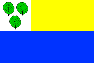
unofficial flag
See also:
Oldebroek municipality
Number of inhabitants (1 Jan 2003): 22.904; area: 98,78 km². Settlements:
Bovenveen, Eekt, Hattemerbroek, Kerkdorp, 't Loo, Mullegen, Noordeinde,
Oldebroek (seat), Oosterwolde, Posthoorn, Voskuil, Wezep.
Oldebroek is in northwest Gelderland in the Veluwe region. The name
is derived from 'Hollanderbroek', wetland reclaimed by Hollanders
(inhabitants of the Holland region) in the 12th century AD. The municipality
got its present borders in 1974. Many a Dutch youngster served here in
military barracks.
The leaves in the canton have been taken from the Coat of Arms; they are alder
leaves (elzebladeren). The flag has not been officially adopted;
it consists of two equally wide horizontal stripes. The bottom stripe is
blue. The top stripe is yellow, with a square canton with the municipal
arms.
Jarig Bakker, 9 October 1999
Oldebroek Coat of Arms
![[Oldebroek Coat of Arms]](../images/n/nl-ge)ol.jpg) image from this website.
image from this website.
Granted 2 Jul 1855.
Advertisement from our sponsor:
Bei Fahnenversand.de erhalten Sie eine Vielzahl an hochwertigen Flaggen, Pins und Aufnähern, zum Beispiel:


Bestellen Sie Ihre Fahnen im Flaggen-Shop bei Fahnenversand.de