
This page is part of an mirror of © FOTW Flags Of The World website
This website is devoted to the science of vexillology (the study of flags).
All illustrations presented on this website serve exclusively to provide information in the context of vexillology.
The authors and hosts of this site explicitly distance themselfes from any symbols of unconstitutional organizations that may be depicted here.
Last modified: 2015-06-29 by andrew weeks
Keywords: elqana | elkana | mo'atza mekomit elqana | west bank occupied territories | judea and samaria |
Links: FOTW homepage |
search |
disclaimer and copyright |
write us |
mirrors
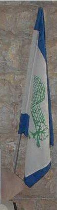
image from <kehilot.moreshet.co.il>
See also:
Local Council Elqana is situated in Judea and Samaria
District, 12 Km. west of Ariel.
Elqana is named after the father of Samuel the prophet (Samuel A,
1,1) and was established in 1977 by Gush Emunim and
became Local Council in 1981. Most of its 3000 inh. are
religious.
The first settlers settled at Meskha, a former Jordanian
Police Fort on top on a hill which was used as synagogue, school
and kindergarten and became so significant in the life of the
founders that they choose it to appear in their emblem together
with olive tree. Today the former fort is used as city hall.
Photo of the municipal flag can be seen at <kehilot.moreshet.co.il/elkana/rabin.jpg>
and <elkana/photo8.jpg>.
The flag is ~1:4:1 horizontal blue-white-blue charged with the
municipal emblem and below it inscription of its name, both in
green.
Source: <kehilot.moreshet.co.il>.
Dov Gutterman, 8 April 2005
elqna.jpg)
image from wikipedia
Advertisement from our sponsor:
Bei Fahnenversand.de erhalten Sie eine Vielzahl an hochwertigen Flaggen, Pins und Aufnähern, zum Beispiel:


