This page is part of an mirror of © FOTW Flags Of The World website
This website is devoted to the science of vexillology (the study of flags).
All illustrations presented on this website serve exclusively to provide information in the context of vexillology.
The authors and hosts of this site explicitly distance themselfes from any symbols of unconstitutional organizations that may be depicted here.
Last modified: 2020-04-19 by rob raeside
Keywords: guanacaste | nandayure |
Links: FOTW homepage |
search |
disclaimer and copyright |
write us |
mirrors
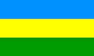 image by Fred Drews, 24 March 2020
See also:
Nandayure Canton (2,489 inhabitants, 56,559 ha) is made of the districts of
Carmona (2,012 inh., 3,419 ha), Santa Rita (1,489 inh., 5,009 ha), Zapotal
(1,267 inh., 10,353 ha), San Pablo (1,734 inh., 7,212 ha), Porvenir (994 inh.,
3,858 ha) and Bejuco (2,489 inh., 26,208 ha). Nandayure Canton was established
by Law No. 2,826 of 9 October 1961 and inaugurated on 8 April 1962; the canton
was previously known as Barrio Colonia Carmona, the 2nd district of Nicoya
Canton. The canton is named for a Chorotegua princess who lived there in the
pre-Colombian times.
Source: Cantonal website
Ivan Sache, 20 July 2013
The flag of Nandayure, designed by Gerald Fonseca, was adopted on 25 July
2007. Nandayure was the last canton in Guanacaste Province without a flag.
The flag is horizontally divided green-yellow-blue with a coat of arms in the
middle. On the photo taken during the flag inauguration, the coat of arms
appears to be different of the official coat of arms shown on the cantonal
website - which, moreover, shows a drawing of the flag without the coat of arms.
Sources:
Photo
of the flag inauguration and
Symbols page, cantonal website.
Ivan Sache, 20 July 2013
g-09.gif) image contributed by Fred Drews, 26 March 2006
image contributed by Fred Drews, 26 March 2006
Advertisement from our sponsor:
Bei Fahnenversand.de erhalten Sie eine Vielzahl an hochwertigen Flaggen, Pins und Aufnähern, zum Beispiel: