This page is part of an mirror of © FOTW Flags Of The World website
This website is devoted to the science of vexillology (the study of flags).
All illustrations presented on this website serve exclusively to provide information in the context of vexillology.
The authors and hosts of this site explicitly distance themselfes from any symbols of unconstitutional organizations that may be depicted here.
Last modified: 2020-12-12 by rob raeside
Keywords: northwest territories | deline | lake |
Links: FOTW homepage |
search |
disclaimer and copyright |
write us |
mirrors
![[Deline]](../images/c/ca-nt-de3.gif) image by Ben Cahoon, 8 November 2020
image by Ben Cahoon, 8 November 2020
See also:
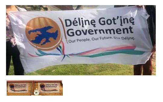
Deline First Nation, NWT has adopted a new flag. A photo of new flag can be
seen here.
Ben Cahoon, 8 November 2020
![[Deline]](../images/c/ca-nt-de.gif) image by Antonio Martins
image by Antonio Martins
Unequal triband of dark blue, white and dark blue charged on the white area with a local badge. This consists of rough contour of Great Bear Lake superimposed on several traditional motives showing among others the letterings "Charter Community of Deline" and "Deline Dene Council", all in shades of blue.
Deline, with a population of 616 (as of 1991), is traditionally named Fort Franklin (or Bear River) and is located at 65°10'N lat. and 123°25'W long., on the western shore of the Great Bear Lake. Local languages are North Slavey and English, and the community belongs to the electoral district and land claim area of Sahtu.
Antonio Martins, 25 June 2000
![[Deline]](../images/c/ca-nt-de2.gif) image by Janis Lasmanis, 4
April 2019
image by Janis Lasmanis, 4
April 2019
Advertisement from our sponsor:
Bei Fahnenversand.de erhalten Sie eine Vielzahl an hochwertigen Flaggen, Pins und Aufnähern, zum Beispiel: