
This page is part of an mirror of © FOTW Flags Of The World website
This website is devoted to the science of vexillology (the study of flags).
All illustrations presented on this website serve exclusively to provide information in the context of vexillology.
The authors and hosts of this site explicitly distance themselfes from any symbols of unconstitutional organizations that may be depicted here.
Last modified: 2016-07-19 by ian macdonald
Keywords: hunter's hill |
Links: FOTW homepage |
search |
disclaimer and copyright |
write us |
mirrors
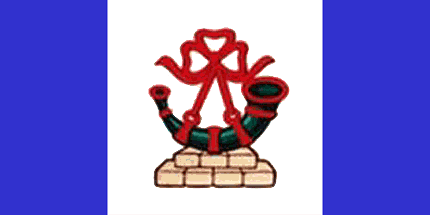 image by
Jens Pattke, 8 June 2016
image by
Jens Pattke, 8 June 2016
See also:
Hunter's Hill is (for now) a local government area in the northern suburbs of
Sydney, on the peninsular between the Parramatta and Lane Cove Rivers. It is the
smallest New South Wales LGA by area, only 6 km².
Along with the Ryde
area, it was one of the first parts of the north shore of the Parramatta River
to be settled by Europeans. The origin of the name is not certain - it might
come from Huntershill, the Scottish former estate of a convict, or more likely
be named for John Hunter, the second governor of New South Wales.
The
area, population 13,000, is largely residential, mostly developed in the 19th
century, and has almost no industrial areas. Many buildings are constructed from
local sandstone, the largest being the boarding school St Joseph's College at
Riverview.
Jonathan Dixon, 9 June 2016
The council flies a flag - a blue-white-blue vertical triband in "Canadian pale" ratios, with the council badge in the centre. The badge, a reference to John Hunter, is a green hunting horn with red strings and a red bow tied in a trefoil-type shape on yellow sandstone blocks in two rows of 3 over 4. The blazon for the badge is:
Upon seven blocks of sandstone ranged in two tiers - three and four Or, a bugle horn mouth to the sinister Vert stringed and garnished Gules.Details of badge (and arms):
Advertisement:
Bei Fahnenversand.de erhalten Sie eine Vielzahl an hochwertigen Flaggen, Pins und Aufnähern, zum Beispiel:


